Healthy Creeks Need Active Stewardship
It’s not uncommon for waterways in high-growth areas to become impaired — which means contaminated by pollutants and no longer meeting State water quality standards for a designated beneficial use.
That’s what happened to Geronimo Creek and its tributary Alligator Creek, located in Comal and Guadalupe Counties. The almost 70-square-mile watershed for these two creeks lies within the larger Guadalupe River Basin. Straddling IH-35, this creek is in the rapidly developing corridor between Austin and San Antonio.
In 2008, Geronimo Creek was listed by the State of Texas as having elevated E. coli bacteria (impairing contact-recreation) and for elevated nitrate-nitrogen levels (which can lead to excessive algae growth).
In response, a watershed partnership was formed by local stakeholders. The Geronimo and Alligator Creeks Watershed Protection Plan (WPP), driven by an open public process, was developed and adopted in 2012.
The WPP identifies key water quality issues, determines the contributing factors, and now provides an ongoing guide for restoring water quality in Geronimo and Alligator Creeks. This includes land management programs and public outreach efforts targeted to restore and protect the vital water resources within this watershed.
All communities and residents within the watershed have a role to play in restoration and ongoing stewardship of Geronimo and Alligator Creeks.
Please browse this website to lean more, subscribe to our newsletter, and get involved.
What is a watershed?
– the area of land from which water drains into a river, lake, or other waterbody. Water flows across or under the land and into the waterbody by way of creeks, rivers, and underground aquifers. River basins can have numerous watersheds.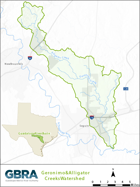
The upper portion of the watershed lies in the extra-territorial jurisdiction (ETJ) of New Braunfels, while the lower portion is in the ETJ of Seguin.